|
BenchmarksFebruary 27, 2014 |
Please E-mail comments, corrections and additions to the webmaster at pje@efgh.com.
Throughout the United States, there are tiny markers called benchmarks, installed many years ago by the USC&GS (United States Coast and Geodetic Survey) or other government agencies while mapping the nation.
With the advent of the world-wide Global Positioning System, these benchmarks are no longer quite as essential as they once were, but many of them remain. Quite a few of them are shown as small triangles on USGS (United States Geological Survey) topographic maps, but finding them can be quite a challenge in some cases.
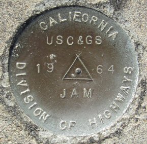
The typical benchmark is a small metal disk, about 2 to 3.5 inches in diameter, set into pavement, a large rock, or a small concrete anchor of some kind. The markings on the disk identify the benchmark, and usually give the year when the benchmark was installed. Government records give the position and elevation of the benchmark, as determined by previous surveys, although some benchmark disks show elevation.
I'm in the process of locating some of the surviving benchmarks in the San Diego area. I'm posting their photographs, together with with the latitude, longitude and elevation of each one, and location information, usually the street address and a photograph of the vicinity, in which the location of the benchmark is shown by a black triangle.
This is a typical benchmark:
A few caveats are in order. The latitude, longitude and elevation were taken with a hand-held GPS, so they are not sufficiently accurate for use in most surveys. The street address is only approximate. Most benchmarks don't have street addresses; some of them aren't even on streets. In many cases, the street address is that of the nearest access point that does have an address.
Some benchmarks shown on topographic maps may have gone missing. Others may be inaccessible. Instead of leaving inaccessible benchmarks off the list, they are included with no photographs and only limited information. Of course, without access, I can't be sure they still exist.
Each benchmark photograph has been modified in several ways. First of all, the image has been rotated to what appears to be the most logical "upright" position. Then the image has been cropped to show only the benchmark, and very little of its surroundings. Finally, the image has been reduced so all disks appear roughly the same size. A few benchmarks are painted over, badly weathered or badly worn, and reduction has caused some loss of information. For a few of these, I've chosen to post the original image, in addition to the processed image. To bring it up, just click on the processed image. If the original image is available, it will appear in your browser window. Even with a fast internet connection, this operation may be rather slow because the original images are rather large.
The entire current list is available in HTML format to be perused online.
The list is also available in database format (without the photographs), which can be downloaded and imported into any database management system. Latitudes and longitudes are given in degrees and decimal fractions of a degree, and not in degrees, minutes and decimal fractions of a minute.
A much larger list of benchmarks is available at the Geocaching Website at
www.geocaching.com/mark. However,
the location information can be rather sketchy. Old descriptions are usually
quite precise, but may be hard to follow if they refer to landmarks
that no longer exist.
The "Identifier" codes were taken from the Geocaching Website. Benchmarks
without codes are those that I couldn't find on the Geocaching Website.
Philip J. Erdelsky