Name:        Q308
Identifier:  DC0549
Lat/Lon:     N 32° 56.605 W 116° 34.090
Elevation:   4319 FEET
Year:        1935
Address:     13101 HIGHWAY 79, JULIAN CA 92036
Vicinity:    click here
Survey Date: 4/6/2014
Description: click here
Page 4 of 7 previous page | next page
|
| Name: Q308 Identifier: DC0549 Lat/Lon: N 32° 56.605 W 116° 34.090 Elevation: 4319 FEET Year: 1935 Address: 13101 HIGHWAY 79, JULIAN CA 92036 Vicinity: click here Survey Date: 4/6/2014 Description: click here |
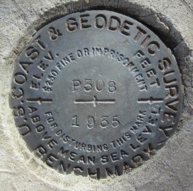
| Name: P308 Identifier: DC0546 Lat/Lon: N 32° 57.513 W 116° 34.750 Elevation: 4832 FEET Year: 1935 Address: 13652 HIGHWAY 79, JULIAN CA 92036 Vicinity: click here Survey Date: 4/6/2014 Description: click here |
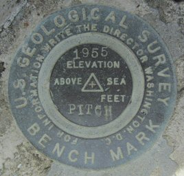
| Name: PITCH Identifier: DC1228 Lat/Lon: N 32° 56.382 W 117° 3.946 Elevation: 473 FEET Year: 1955 Address: 12251 OLD POMERADO RD, POWAY CA 92064 Vicinity: click here Survey Date: 4/10/2014 Description: click here |
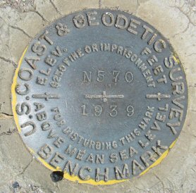
| Name: N570 Identifier: DC0427 Lat/Lon: N 32° 49.372 W 116° 31.867 Elevation: 3666 FEET Year: 1939 Address: 28789 OLD HIGHWAY 80, PINE VALLEY CA 91962 Vicinity: click here Survey Date: 4/15/2014 Description: click here |
| Name: Identifier: Lat/Lon: N 32° 44.416 W 117° 12.944 Elevation: 54 FEET Year: Address: 2679 ROSECRANS ST, SAN DIEGO CA 92106 Vicinity: click here Survey Date: 4/17/2014 Description: click here |
| Name: Identifier: Lat/Lon: N 32° 44.410 W 117° 12.946 Elevation: 54 FEET Year: Address: 2665 ROSECRANS ST, SAN DIEGO CA 92106 Vicinity: click here Survey Date: 4/17/2014 Description: click here |
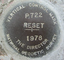
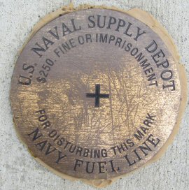
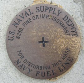
| Name: P722 Identifier: DC0832 Lat/Lon: N 32° 43.704 W 117° 12.806 Elevation: 19 FEET Year: 1978 Address: 4300 N HARBOR DR, SAN DIEGO CA 92101 Vicinity: click here Survey Date: 4/17/2014 Description: click here |
| Name: K899 Identifier: DC0840 Lat/Lon: N 32° 43.726 W 117° 11.651 Elevation: 12 FEET Year: 1955 Address: 3380 N HARBOR DR, SAN DIEGO CA 92101 Vicinity: click here Survey Date: 4/17/2014 Description: click here |
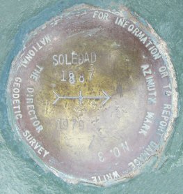
| Name: SOLEDAD Identifier: DC1507 Lat/Lon: N 32° 50.389 W 117° 14.684 Elevation: 796 FEET Year: 1979 Address: SOLEDAD PARK RD, LA JOLLA CA 92037 Vicinity: click here Survey Date: 4/22/2014 Description: click here |
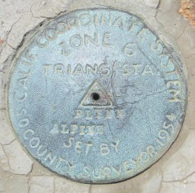
| Name: FLINN ALPINE Identifier: Lat/Lon: N 32° 50.454 W 116° 50.327 Elevation: 2254 FEET Year: Address: 14787 OLD HIGHWAY 80, EL CAJON CA 92021 Vicinity: click here Survey Date: 4/28/2014 Description: click here |
| Name: CUYAMACA 2 Identifier: DC1974 Lat/Lon: N 32° 56.796 W 116° 36.404 Elevation: 6465 FEET Year: 1981 Address: 13652 HIGHWAY 79, JULIAN CA 92036 Vicinity: click here Survey Date: 5/3/2014 Description: click here |
| Name: CUYAMACA NO 3 Identifier: DC1974 Lat/Lon: N 32° 56.800 W 116° 36.401 Elevation: 6472 FEET Year: 1964 Address: 13652 HIGHWAY 79, JULIAN CA 92036 Vicinity: click here Survey Date: 5/3/2014 Description: click here |
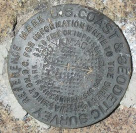
| Name: CUYAMACA Identifier: DC1974 Lat/Lon: N 32° 56.795 W 116° 36.396 Elevation: 6493 FEET Year: Address: 13652 HIGHWAY 79, JULIAN CA 92036 Vicinity: click here Survey Date: 5/3/2014 Description: click here |
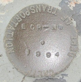
| Name: ECR-NW Identifier: Lat/Lon: N 32° 56.016 W 117° 14.200 Elevation: 42 FEET Year: 1994 Address: 11950 EL CAMINO REAL, SAN DIEGO CA 92130 Vicinity: click here Survey Date: 5/9/2014 Description: click here |
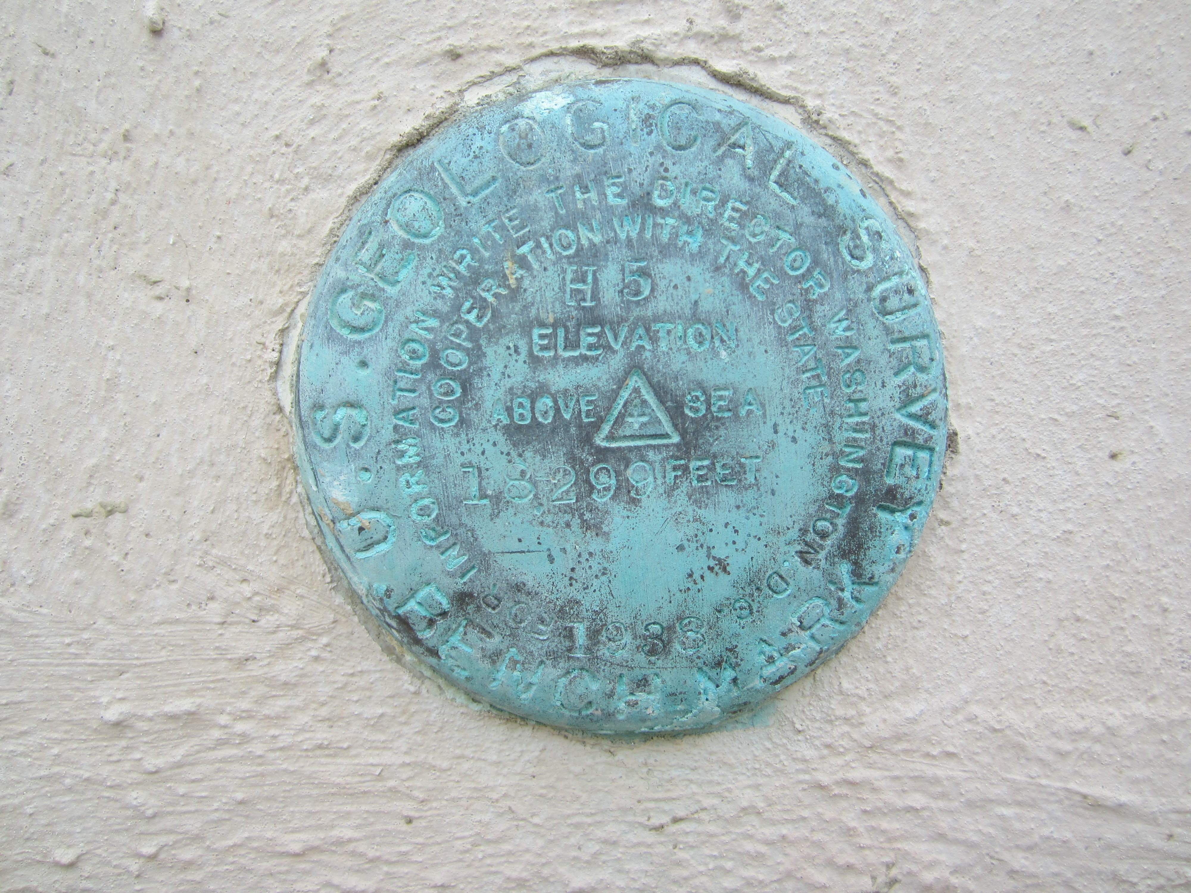
| Name: H5 Identifier: DC0898 Lat/Lon: N 32° 43.277 W 117° 10.332 Elevation: 36 FEET Year: 1938 Address: 1600 PACIFIC HWY, SAN DIEGO CA 92101 Vicinity: click here Survey Date: 5/10/2014 Description: click here |
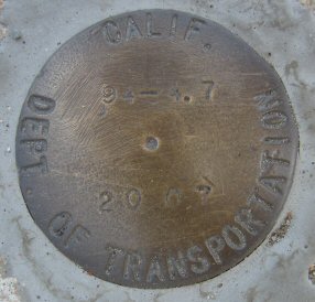
| Name: 94-4.7 Identifier: Lat/Lon: N 32° 43.098 W 117° 5.623 Elevation: 231 FEET Year: 2007 Address: 1200 47TH ST, SAN DIEGO CA 92102 Vicinity: click here Survey Date: 5/10/2014 Description: click here |
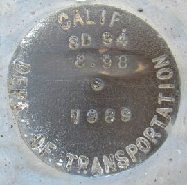
| Name: SD94 8.98 Identifier: Lat/Lon: N 32° 44.790 W 117° 1.866 Elevation: 499 FEET Year: 1989 Address: 3739 LEMON GROVE AVE, LEMON GROVE CA 91945 Vicinity: click here Survey Date: 5/10/2014 Description: click here |
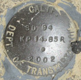
| Name: SD94 KP14.85R Identifier: Lat/Lon: N 32° 44.816 W 117° 1.615 Elevation: 480 FEET Year: 2002 Address: 3754 GROVE ST, LEMON GROVE CA 91945 Vicinity: click here Survey Date: 5/10/2014 Description: click here |
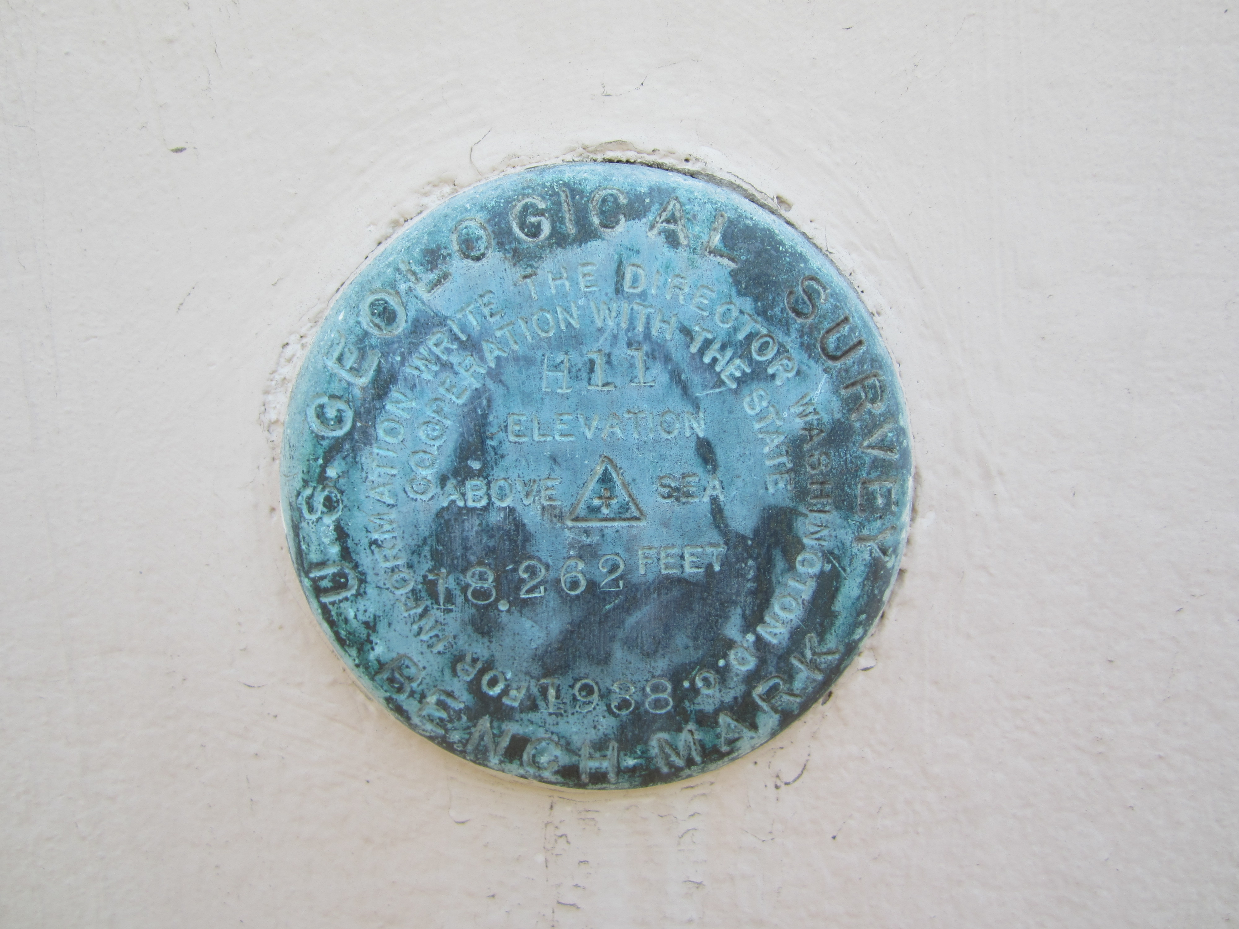
| Name: H11 Identifier: DC0862 Lat/Lon: N 32° 43.364 W 117° 10.292 Elevation: 19 FEET Year: 1988 Address: 1600 PACIFIC HWY, SAN DIEGO CA 92101 Vicinity: click here Survey Date: 5/13/2014 Description: click here |
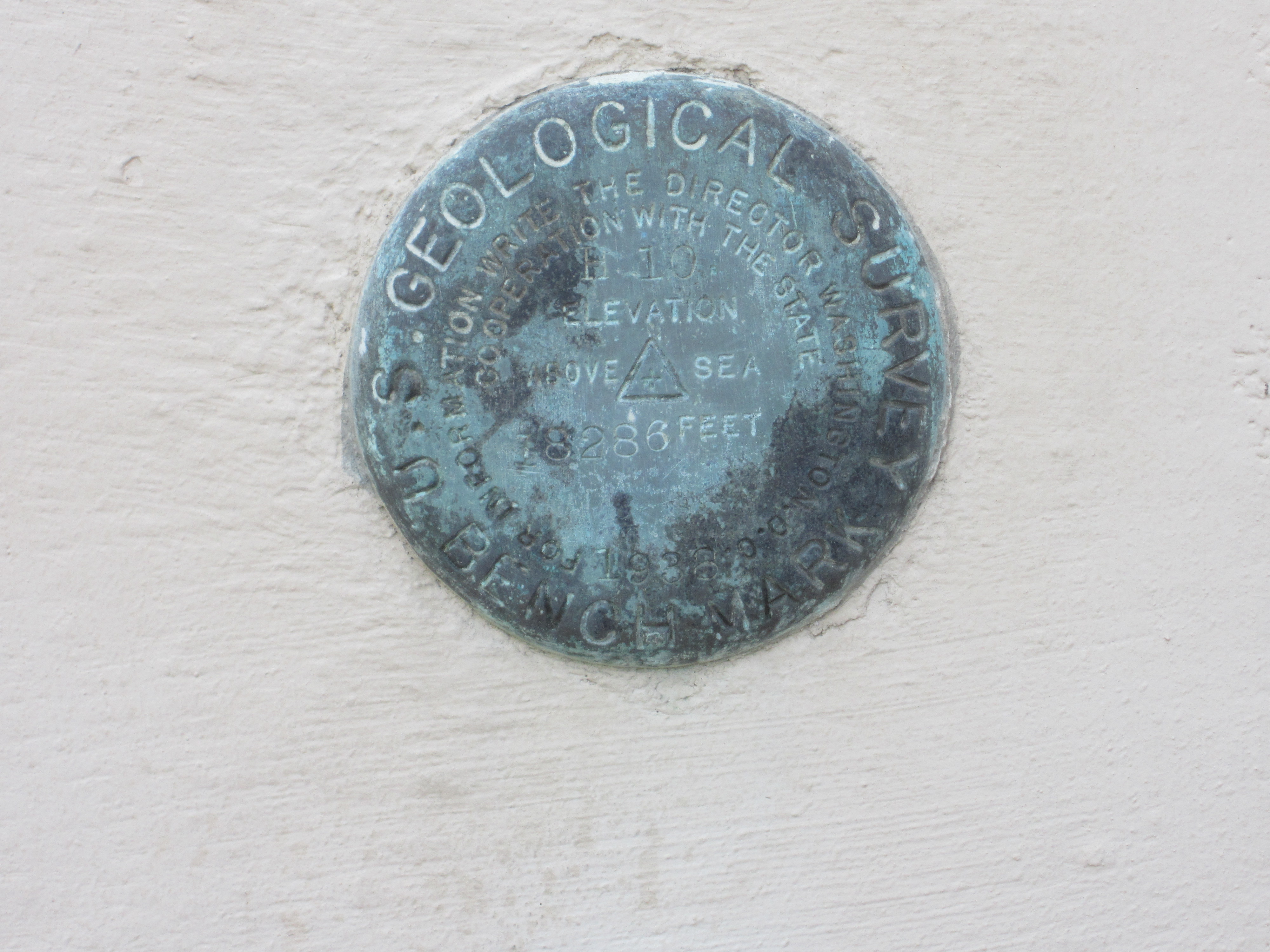
| Name: H10 Identifier: DC0905 Lat/Lon: N 32° 43.356 W 117° 10.315 Elevation: 17 FEET Year: 1938 Address: 1600 PACIFIC HWY, SAN DIEGO CA 92101 Vicinity: click here Survey Date: 5/13/2014 Description: click here |

| Name: H9 Identifier: DC0900 Lat/Lon: N 32° 43.358 W 117° 10.316 Elevation: 22 FEET Year: 1938 Address: 1600 PACIFIC HWY, SAN DIEGO CA 92101 Vicinity: click here Survey Date: 5/13/2014 Description: click here |
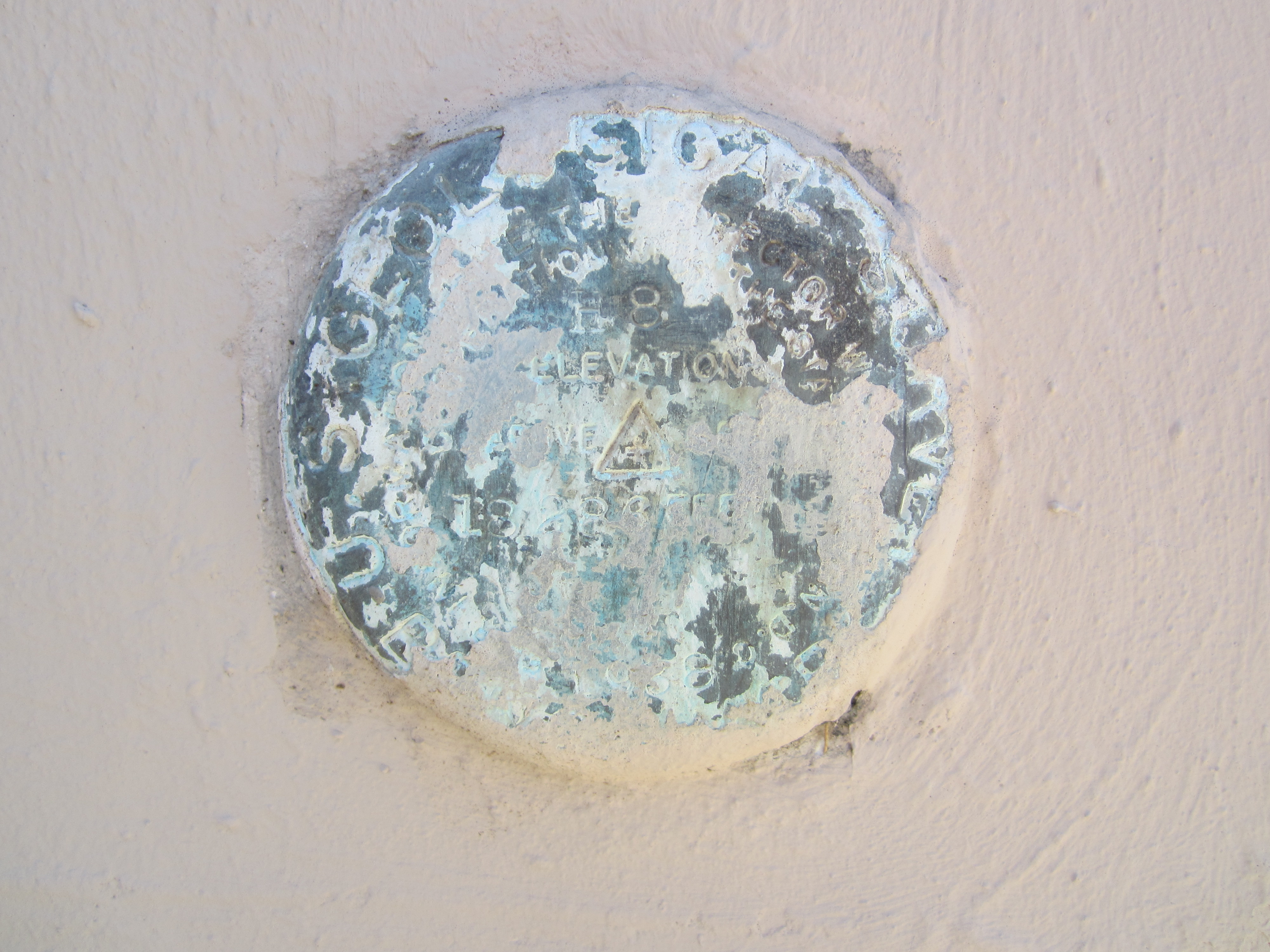
| Name: H8 Identifier: DC0899 Lat/Lon: N 32° 43.358 W 117° 10.330 Elevation: 19 FEET Year: 1938 Address: 1600 PACIFIC HWY, SAN DIEGO CA 92101 Vicinity: click here Survey Date: 5/13/2014 Description: click here |
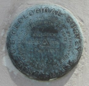
| Name: H7 Identifier: DC0904 Lat/Lon: N 32° 43.325 W 117° 10.330 Elevation: 13 FEET Year: 1938 Address: 1600 PACIFIC HWY, SAN DIEGO CA 92101 Vicinity: click here Survey Date: 5/13/2014 Description: click here |
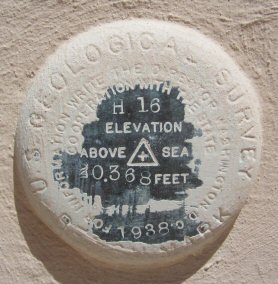
| Name: H16 Identifier: DC0903 Lat/Lon: N 32° 43.323 W 117° 10.332 Elevation: 15 FEET Year: 1938 Address: 1600 PACIFIC HWY, SAN DIEGO CA 92101 Vicinity: click here Survey Date: 5/13/2014 Description: click here |
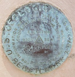
| Name: H15 Identifier: DC0902 Lat/Lon: N 32° 43.315 W 117° 10.332 Elevation: 17 FEET Year: 1938 Address: 1600 PACIFIC HWY, SAN DIEGO CA 92101 Vicinity: click here Survey Date: 5/13/2014 Description: click here |