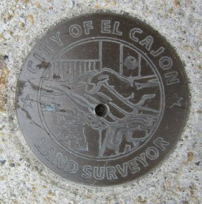
Name:
Identifier:
Lat/Lon:     N 32° 47.692 W 116° 57.790
Elevation:   446 FEET
Year:
Address:     155 W MAIN ST, EL CAJON CA 92020
Vicinity:    click here
Survey Date: 3/11/2014
Description: click here
Page 3 of 7 previous page | next page
|
| Name: Identifier: Lat/Lon: N 32° 47.692 W 116° 57.790 Elevation: 446 FEET Year: Address: 155 W MAIN ST, EL CAJON CA 92020 Vicinity: click here Survey Date: 3/11/2014 Description: click here |
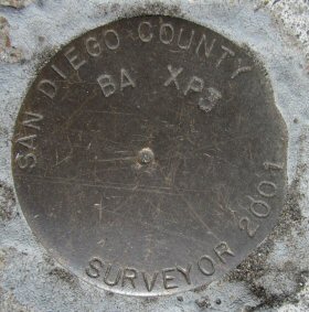
| Name: BA XP3 Identifier: Lat/Lon: N 32° 49.152 W 116° 57.554 Elevation: 428 FEET Year: 2001 Address: 190 E BRADLEY AVE, EL CAJON CA 9202 Vicinity: click here Survey Date: 3/11/2014 Description: click here |
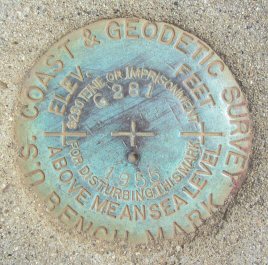
| Name: G281 Identifier: DC0513 Lat/Lon: N 32° 49.488 W 116° 57.736 Elevation: 428 FEET Year: 1955 Address: MAGNOLIA AVE & AIRPORT DR, EL CAJON CA 92020 Vicinity: click here Survey Date: 3/11/2014 Description: click here |
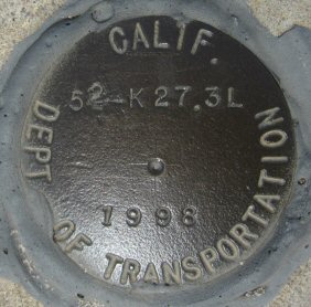
| Name: 52-K27.3L Identifier: Lat/Lon: N 32° 49.998 W 116° 57.857 Elevation: 425 FEET Year: 1998 Address: 8797 MAGNOLIA AVE, SANTEE CA 92071 Vicinity: click here Survey Date: 3/11/2014 Description: click here |

| Name: COD Identifier: DC1466 Lat/Lon: N 32° 46.208 W 117° 1.434 Elevation: 550 FEET Year: Address: EL CAJON BLVD & BALTIMORE DR, LA MESA CA 91941 Vicinity: click here Survey Date: 3/11/2014 Description: click here |
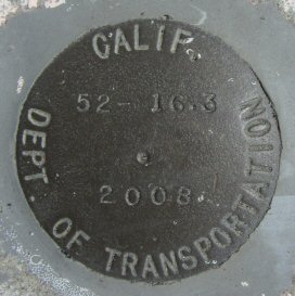
| Name: 52-16.3 Identifier: Lat/Lon: N 32° 50.065 W 116° 59.037 Elevation: 371 FEET Year: 2008 Address: 8750 CUYAMACA ST, SANTEE CA 92071 Vicinity: click here Survey Date: 3/11/2014 Description: click here |
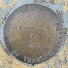
| Name: 805-17.0 Identifier: Lat/Lon: N 32° 45.802 W 117° 7.620 Elevation: 409 FEET Year: 2001 Address: 3124 ADAMS AVE, SAN DIEGO CA 92116 Vicinity: click here Survey Date: 3/13/2014 Description: click here |
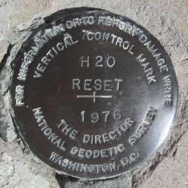
| Name: H20 Identifier: Lat/Lon: N 32° 45.348 W 117° 5.872 Elevation: 389 FEET Year: 1976 Address: 4474 EL CAJON BLVD, SAN DIEGO CA 92115 Vicinity: click here Survey Date: 3/16/2014 Description: click here |
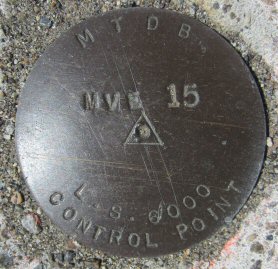
| Name: MVE15 Identifier: Lat/Lon: N 32° 46.735 W 117° 3.993 Elevation: 374 FEET Year: Address: 5451 COLLEGE AVE, SAN DIEGO CA 92120 Vicinity: click here Survey Date: 3/16/2014 Description: click here |
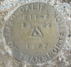
| Name: FIT-2 Identifier: DC2105 Lat/Lon: N 32° 50.773 W 116° 54.682 Elevation: 751 FEET Year: 1964 Address: 9167 LOS COCHES RD, LAKESIDE CA 92040 Vicinity: click here Survey Date: 3/20/2014 Description: click here |
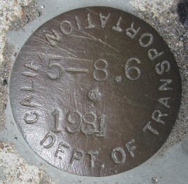
| Name: 5-8.6 Identifier: Lat/Lon: N 32° 38.383 W 117° 5.981 Elevation: 20 FEET Year: 1981 Address: 741 E ST, CHULA VISTA CA 91910 Vicinity: click here Survey Date: 3/21/2014 Description: click here |
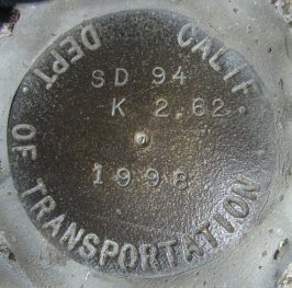
| Name: SD 94 K 2.62 Identifier: Lat/Lon: N 32° 42.781 W 117° 8.648 Elevation: 143 FEET Year: 1998 Address: 730 22ND ST, SAN DIEGO CA 92102 Vicinity: click here Survey Date: 3/21/2014 Description: click here |
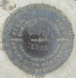
| Name: Z307 Identifier: DX0323 Lat/Lon: N 33° 5.174 W 116° 59.382 Elevation: 415 FEET Year: 1935 Address: SAN PASQUAL VALLEY RD & YSABEL CREEK RD, ESCONDIDO CA 92027 Vicinity: click here Survey Date: 3/22/2014 Description: click here |
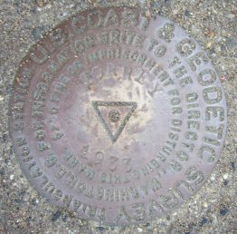
| Name: TORREY Identifier: DC1230 Lat/Lon: N 32° 55.294 W 117° 15.258 Elevation: 364 FEET Year: 1933 Address: 12500 NORTH TORREY PINES RD, LA JOLLA CA 92037 Vicinity: click here Survey Date: 3/25/2014 Description: click here |
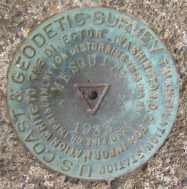
| Name: MESQUITE Identifier: DC1542 Lat/Lon: N 32° 55.957 W 117° 13.089 Elevation: 442 FEET Year: 1933 Address: 4732 FAIRPORT WAY, SAN DIEGO CA 92130 Vicinity: click here Survey Date: 3/25/2014 Description: click here |
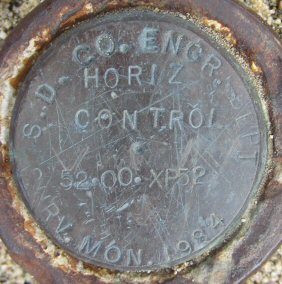
| Name: 52-00-XP52 Identifier: Lat/Lon: N 32° 58.736 W 117° 0.674 Elevation: 1146 FEET Year: 1984 Address: 14452 RANGE PARK RD, POWAY CA 92064 Vicinity: click here Survey Date: 3/27/2014 Description: click here |
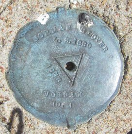
| Name: VOLCAN NO 1 Identifier: DX4993 Lat/Lon: N 33° 6.106 W 116° 34.717 Elevation: 5353 FEET Year: 1938 Address: 1209 FARMER RD, JULIAN CA 92036 Vicinity: click here Survey Date: 3/30/2014 Description: click here |
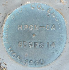
| Name: HPGN-CA SDGPS14 Identifier: Lat/Lon: N 33° 6.106 W 116° 34.724 Elevation: 5352 FEET Year: 1990 Address: 1209 FARMER RD, JULIAN CA 92036 Vicinity: click here Survey Date: 3/30/2014 Description: click here |
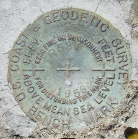
| Name: R521 Identifier: DX0231 Lat/Lon: N 33° 4.897 W 116° 38.716 Elevation: 3655 FEET Year: 1956 Address: JULIAN HWY & FARLEY RD, JULIAN CA 92036 Vicinity: click here Survey Date: 3/30/2014 Description: click here |
| Name: Identifier: DX0234 Lat/Lon: N 33° 5.885 W 116° 38.759 Elevation: 3675 FEET Year: Address: 1531 ORCHARD LN, JULIAN CA 92036 Vicinity: click here Survey Date: 3/30/2014 Description: click here |
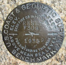
| Name: F308 RESET Identifier: DX0239 Lat/Lon: N 33° 5.899 W 116° 39.867 Elevation: 3361 FEET Year: 1939 Address: INAJA MEMORIAL PARK, SANTA YSABEL CA 92070 Vicinity: click here Survey Date: 3/30/2014 Description: click here |
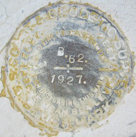
| Name: B62 Identifier: DX0302 Lat/Lon: N 33° 2.684 W 116° 51.838 Elevation: 1463 FEET Year: 1927 Address: 701 MAIN ST, RAMONA CA 92065 Vicinity: click here Survey Date: 3/30/2014 Description: click here |
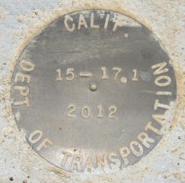
| Name: 15-17.1 Identifier: Lat/Lon: N 32° 56.085 W 117° 6.970 Elevation: 835 FEET Year: 2012 Address: 9943 MERCY RD, SAN DIEGO CA 92129 Vicinity: click here Survey Date: 4/3/2014 Description: click here |
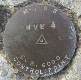
| Name: MVE4 Identifier: Lat/Lon: N 32° 46.812 W 117° 6.110 Elevation: 92 FEET Year: Address: 4282 CAMINO DEL RIO N, SAN DIEGO CA 92108 Vicinity: click here Survey Date: 4/4/2014 Description: click here |
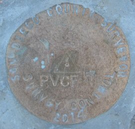
| Name: PVCF5 Identifier: Lat/Lon: N 32° 52.591 W 116° 35.184 Elevation: 3681 FEET Year: 2014 Address: 10610 HIGHWAY 79, DESCANSO CA 91916 Vicinity: click here Survey Date: 4/6/2014 Description: click here |